


NV-IMP02 Impulse System Operations
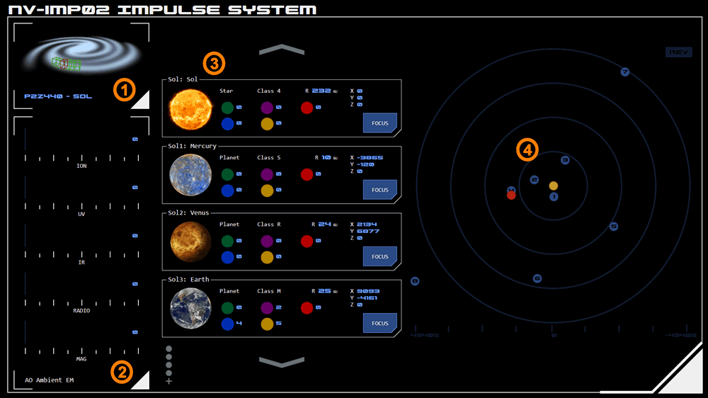 The Impulse System Operations panel provides information on the Astronomical Objects (AOs) in the stellar system the vessel is currently operating in.
1. System Identification
This module identifies the current stellar system, including its reference number, informal designation (if available) and navigation sector.
2. AO Ambient EM
This module displays the ambient EM of the system's Navigable Astronomical Object (NAO) - which is usually the system's star.
The default display can be overridden temporarily by selecting a focus button on the AO list (see below). When a specific focus is selected, the ambient EM of that AO will be displayed instead.
3. AO List
This module displays a scrollable list of the system's major AOs. It provides the AO's reference number, informal designation (if available), type and class along with a visual representation (which is not to scale).
Position Information
The grid position and radius of each AO is provided.
EM Output
The EM output (at source) of each AO is listed using standard color codes to identify the EM band:
Green: Ionising radiation EM band
Red: Infrared EM band
Violet: Ultraviolet EM band
Blue: Radio EM band
Yellow: Magnetic
Focus
The FOCUS button will highlight the selected AO on the AO Map (see below) and change the focus of the Ambient EM to the selected AO.
4. AO Map
This module provides a simplified representation of AO positions.
The Y axis is represented horizontally. The X axis is represented vertically.
Colour Codes
The NAO is represented as yellow (and is typically in the centre of the map).
Other AOs are represented as blue, An AO that has been focussed (see above) will be displayed in grey.
The vessel's current position is represented as red.
Scale
The scale of the map is represented at the bottom of the module in Grid Units (GUs).
Map Orientation
By default the X axis is displayed with negative values at the top of the module and positive values at the bottom according to the standard Cartesian model.
Some operators may find it more intuitive to reverse the axes so that the map's orientation matches vessel orientation indicators (such as the "compass").
The current orientation is indicated by a symbol in the top-right of the map, which displays REV when in reverse orientation mode and STD when in standard orientation mode. Tapping the symbol toggles between the modes.
Attachments:
Concept Site
Immersive sci-fi and how to join the adventure
Crew Site
Information and tools for ISDC crew members


